

SOUTHERN JAPAN
- Shikoku & Kyushu -
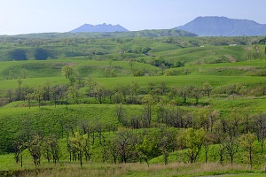
kagawa
Sanuki Fuji

Mt. Iino is the pride and joy of the locals. It is believed to be as beautiful as Mt. Fuji, and it
is affectionately called Sanuki Fuji. Everywhere in Japan, there are beautiful mounts with
references to Mt. Fuji. Several good examples can be found in this book: Mt. Bandai is
known as Aizu Fuji; Mt. Yotei is known as Ezo Fuji; Mt. Daisen is called Izumo Fuji;
Sakurajima is referred to as Chikushi Fuji.
Mt. Fuji is dear in the hearts of the Japanese. Japan’s premiere mount is symbolic of a
number of things, ranging from hopes and dreams on a personal level to a commonly shared
love for the land and nature. It is easy to understand why a replica should exist in the backyard.
(By the same token, most towns seem to have a shopping street named The Ginza!)
Mornings are calm around Sanuki Fuji. Face it from Miyaike to see a clear mirror image
reflected on the water’s surface. The gentle slope looks sweet, like something out of an anime
movie. The slightly tapered shape and the ponds at the base of the mountain are part of the
unique features found in the Sanuki Plains.
香川縣丸龜市的飯野山因與富士山相似,因此被稱為「讚岐富士」。各地坐落著與富士山相似的山,這些山因為人們對富士山的憧憬以及對家鄉的熱愛,而被稱為「故鄉富士」。盤梯山作為「會津富士」;羊蹄山作為「蝦夷富士」;大山作為「出雲富士」;櫻島御岳作為「筑紫富士」為當地人所熱愛著。這張照片拍攝的是從宮池見到的讚岐富士。日出前,天空染上柔和美麗的顏色。無風,倒映在水面上的山景十分美麗。
香川縣丸龜市的飯野山因與富士山相似,因此被稱為「讚岐富士」。各地坐落著與富士山相似的山,這些山因為人們對富士山的憧憬以及對家鄉的熱愛,而被稱為「故鄉富士」。盤梯山作為「會津富士」;羊蹄山作為「蝦夷富士」;大山作為「出雲富士」;櫻島御岳作為「筑紫富士」為當地人所熱愛著。這張照片拍攝的是從宮池見到的讚岐富士。日出前,天空染上柔和美麗的顏色。無風,倒映在水面上的山景十分美麗。
To climb Mt. Iino, take the Community Bus (Iino/Nakatsu Route) for Iinoyama Tozan-guchi bus stop from Marugame train station. Mt. Iino is 400m above sea level. The hike takes about an hour on established trails.
kochi
Shimanto River, Kochi

The Japanese like to group things in threes, like the three best, or the three biggest, or the top
three in any category. Not surprisingly, even the clarity of water flowing through streams and
rivers get grouped into Japan’s three most clear-flowing rivers. Shimanto River is one of those,
spanning through Kochi Prefecture for 196 kilometers. The other two rivers in this category are the Nagara River (Gifu) and Kakita River (Shizuoka).
At its most upstream location in Nakasato-cho, in the Onomi district, a concrete bridge that
was built in the late 1950s does more than connect opposite sides of the river. Naro Bridge
is a gathering place. Late in the afternoons, people start to congregate toward the benches
in the middle of the bridge. It is time to socialize, and soon they become engrossed in a long
conversation. Their daily walks take them to a spot where they can connect with friends, old
and new. Getting permission to take their picture can even spark new friendships.
Surrounded by the mountain forests, this tranquil village has crystal clear waters flowing
through it, and fresh clean air to fill the lungs. Maybe these are the secrets to longevity. On
summer nights, tiny little lights spark across the water and beyond, as far away as the rice
paddies that stretch out on both sides of the river. Fireflies are dancing about.
四萬十川是四國最長的河川,全長196公里。與岐阜縣的長良川、靜岡縣的柿田川並稱日本三大清流。四萬十川帶給人的印象是河寬相當寬闊,而上游的水色十分清澈,略帶藍色。前往最上游一帶所在的中土佐町,在其大野見地區的奈路橋附近攝影,只見當地的老婆婆們紛紛來到橋上碰面,談天說地。她們想必就是如此愉快地度過每天的散步時光吧。河的兩側皆有田,據說夏日早晨時會蒙上一層朝霧,瀰漫一股夢幻的氣氛。夏夜裡,支流處更有螢火蟲飛舞。
20 minutes from Tosakure train station by taxi.
tokushima
Ochiai Village

Far into the mountainous region of Tokushima, Ouboke Gorge and the Iya Kazura-bashi are two scenic landmarks in the central Iya region. Further into the hills, Ochiai Village is like most places in Japan where the scenery remains unblemished: it is a hideaway.
Negotiating the winding riverside road is not easy on the way to the Ochiai Village Observation Point. From the opposite side of the hamlet, the houses look as if they are desperately hanging on to the side of the hill. If you get there at dawn after the rain, the mist rises from the valley
and weaves around, moving up and down, fluctuating, thinning out here, thickening there. Lights from the village peek through the fog to add wonderment to the scene.
There are a few villages in Shikoku where the houses are built on a steep slope, but Ochiai is especially amazing.
在德島縣內陸的深山區域裡有著知名的大步危以及祖谷藤蔓橋。而落合聚落就位在比前述兩個景點更深處的位置。單就地點的氣氛來說,落合聚落完全稱得上是祕境。而且從落合聚落觀景台上可以眺望整個聚落的景色。貼附著陡坡建起的住宅們形成了壓倒性的景色。攝影當天是剛剛下過雨後的夜晚。因此山谷裡頭飄起了霧氣,霧氣在聚落的戶外燈光照射下,更是形成一片宛如幻想世界般的風景。
From Ouboke train station, take the bus for Kubo and get off at Ochiai-bashi bus stop. The bus ride takes about an hour.
●About Iya → Tokushima Prefecture’s web page
●Around Iya, Nishi Awa → Nishi Awa
Nishi-Awa comprises four administrative areas in Tokushima ,Mima, Miyoshi, Tsurugi, and Higashimiyoshi.
ehime
Hakata Island

In the southwest corner of Japan lies the smallest of the main islands, Shikoku. Taking up more than a third on the west side of Shikoku is Ehime Prefecture. Off the coast of Ehime, a few of the small islands in the Seto Inland Sea belong to Imaji city. One of them is called Hakata Island. It sounds like the city in Fukuoka, but the kanji spelling is not the same, and this place definitely has a mark of its own.
Try approaching from Hiroshima. You will go across a series of bridges known as the Shimanami
Kaido (Nishiseto Expressway) to arrive in Imabari on the Ehime side. The crossing is an island hopping experience. Not only is the bridge an architectural marvel, the breathtaking scenery along the way is superb. The scenic route is about 60 kilometers long for cars, and 70 kilometers for the separate path for pedestrians and bicycles. If you are looking for a great
outdoor experience, join the ranks of tourists from all over the world and take the bike route.
島波海道和伯方島是享譽世界的觀光名勝。在開山公園所見的這片景色也相當著名。要拍攝櫻之絨毯,建議於春季清晨過來。趁天色尚暗時抵達觀景台,架好相機等候日出。太陽即將升起時,天空和山巒會染上淡淡的粉紅色,瀨戶內海的眾多島嶼在春霞籠罩下朦朧如水墨畫。若要造訪島波海道,請盡可能選擇這個季節和這個時段,來欣賞美不勝收的風景。
From Imabari, Hiroshima or Fukuyama train station, take the Shimanami Liner highway bus for Hakata Bus Center, then 10 minutes by car.
●”Setouchi” was selected for 52 Places to Go in 2019.(With reference to No.7) 52 Places to Go in 2019 by NY TIMES
●About Setouchi 13 Reasons to Travel to Japan’s Setouchi Region
●26th April 2019 Start Setouchi Triennale Setouchi Triennale official site
●About Hakatajima → Tourist information
●About Setouchi→ Setouchi Finder
●Running on Shimanami Kaido by bicycle → Shimanami Kaido Cycling
fukuoka
Yame Tea Field

The Yame Central Tea Garden is a plantation situated on gentle slopes. Tea harvested in this
area is of the highest quality. The best tea from Fukuoka— in taste, fragrance and color— is
sold as Yame cha (Yame tea).
The Tea Garden is open to visitors. You can follow the private farm roads within the
plantation to the observation area. On a clear day, you can see all the way to the Ariake
Sea. The fields of green spread out before your eyes, the beauty of the land pronounced by
symmetry and lazy curves. The poles standing in the fields are wind machines. The large fan
blades help circulate the air and protect the crops from frost. Natural breezes flow through as
well. The gentle puffs seem to send word that shincha, the first harvest, is ready. Yame cha is
sold in the outlet store inside the Tea Garden.
八女中央大茶園是一處位於平緩的丘陵地上的大規模茶園。在此處採摘的八女茶,以福岡縣的知名品牌茶而聞名,是味道、香氣與色澤都非常優秀的高級茶。在園內可以漫步於農業道路上,前往觀景台。這裡有直銷處也可以在此處買到八女茶。新茶季節時的茶園裡,新綠耀眼,初夏的微風令人心曠神怡。寬廣的茶園造形優美,無論把相機對準哪邊都能拍到如畫般的美景。晴天時似乎能將整個有明海的景色盡收眼底。茶園中纖細的塔是防霜扇。為了不讓霜落在茶園裡,利用扇葉造風讓空氣流通,保護新芽。
From Hainuzuka train station, a car ride will take 20 minutes to the Yame Central Tea Garden.
●About Yame → Visit Yame Official Site
Hiraodai

A small rural town thrives at the base of the Hiraodai Limestone Plateau. After driving through
rice paddies, the road starts its ascent. At the top of the hill, a panoramic vista of rolling plains
hits the sky. It is an open view but the plains are not bare. They are embellished with limestone
rock formations, as if a fistful of boulders were dropped from the sky and scattered upon the
grassy fields. The karst formation at Hiraodai can look like a herd of sheep, and that is how this
area got its name of Yogunbaru (Fields of Sheep).
Take a nature walk and see if you can make out some of the interesting shapes like Kissing
Rocks and Gutsy Tree. The caves underground are a feature of karst topography. A number
of them are open to the public, like Senbutsu Cave and Mejiro Limestone Cave. Stop at the
Nature Observation Center before venturing off to explore the area. Hiraodai is one of Japan’s
three great karst landscapes. The other two are Akiyoshidai Plateau (Yamaguchi) and Shikoku
Karst Natural Park (Kochi-Ehime).
平尾台為喀斯特台地,石灰岩四散在廣大的草原之上;因為岩石散佈四處的樣子看起來就像是草原上有許多群聚的羊隻,因此這裡也被稱為「羊群原」。自山麓沿著曲折的山路驅車而上,就能抵達平尾台自然觀察中心。在這間中心裡取得觀光資訊後,漫步於遊覽步道之上,享受自然景觀,會是很棒的安排。站在展望平台上可將這片喀斯特台地盡收眼底。頭上的天空也是 360 度無死角的唷。而且這裡的空氣也相當清新。這裡有「接吻岩」、「獅子岩」等奇形怪狀的岩石,更有從岩石裡長出來的樹「堅毅樹」等,很是幽默有趣。我在拍照的時候,陽光灑落在草原之上,使岩石更具存在感,讓人覺得像是羊群正在朝著山頂緩慢移動往上爬似的。「做出想像再按下快門」這一點對拍照來說是很重要的。我觀察了上方天空中的雲朵狀況,抓住光線的變化拍下了幾張照片。
20 minutes by car from Ishiharamachi train station.
●About Hiraodai → Kitakyushu City Tourism Information
saga
Chikugo River Drawbridge

Viewed from Okawa, Fukuoka
At the mouth of the Chikugo River is a drawbridge called Shokai-kyo. It connects
Fukuoka and Saga. Previously used exclusively for rail transport, today it is a pedestrian
bridge that is lowered eight times a day so people can cross on foot. The bridge has an
industrial silhouette. Photographers like to take its profile in the sunset, moving with the
sun, following the sun’s directional angle. If the clouds stay out of the way, the shots
turn out better than expected. At night, the bridge is outlined in colorful blinking lights,
alternating every few seconds from red to blue and different colors. The hypnotic motion
of the changing lights might hold you captive for a while.
筑後川昇開橋是筑後川上的一座橋,連接佐賀縣佐賀市與福岡縣大川市兩市。從前用為鐵路專用的活動式鐵橋。現今則供人在塔橋散步,一天之中可升降的區塊會降下八次,讓人們可以步行渡橋。這張照片是從大川市向島向著佐賀一帶拍攝的。建築物的造形之美令我陶醉,於是在夕陽西沉時段捕捉下這幅景色的剪影。我配合太陽動向,一邊挪動自己的站位一邊拍攝。攝影期間,太陽隱身在雲朵之後,我鬆了口氣。日落黃昏,橋上開始點起燈飾。燈光每隔數秒就變換成紅色、藍色等繽紛色彩,令人著迷。
In Saga: from Saga train station, 25 minutes by city bus to Shokai-kyo bus stop. The drawbridge is a 5-minute walk.
In Fukuoka: from Nishitetsu Yanagawa train station, take the bus for Saga train station to Okawa-bashi bus stop, about a 25-minute ride. The drawbridge is a 10-minute walk. This view from Fukuoka.
About Chikugo River Drawbridge → Saga Official Travel Guide
nagasaki
Kujuku Island, Nagasaki

A ria formation created more than 200 small islands in Sasebo. No one really counted the number of isles before naming them the Kujuku-shima (Ninety-nine Islands) in this northwest part of Kyushu; 99 just seemed like a big enough number to include all of them on the coastline of Nagasaki. Sasebo city has several good viewing spots, like Ishidake and Funakoshi observatories, complete with walking paths and ample parking. This photo was taken from Ishidake Observatory. (The Last Samurai was filmed here.) A short walk along the footpath from the parking lot toward the forest reveals a wide open vista that is utterly remarkable. The ocean is true blue during the day, while the evening sun turns the water a bright red. Cruise ships weave through the isles and leave a long white foamy trail behind in their wake. Ah, the open seas are vast.
長崎縣佐世保市沿海延綿著谷灣式海岸與島嶼交織而成的美麗自然景觀。「九十九島」這個名字的由來並不是說在錯綜複雜的海岸上有九十九座島,而是指島嶼數量眾多的意思。實際上這裡有多達 200 座島。 市內各處有著能將海岸景色盡收眼底的觀景台,每一處都整建了停車場與步道。石岳展望台園地曾是電影《末代武士》的拍攝場地。從停車場出發在森林內的步道走五分鐘,眼前便會出現一片開闊的景緻。大型遊船在各個島嶼間勇往前行。殘留在海面上長長的白色船波,告訴我們這片海有多大。白天因藍天反射海面呈藍色,傍晚太陽則將海面染成紅色,大海的表情即使在同一天也沒有一樣的時候。
15 minutes by car from Sasebo train station to the Ishidake Observatory. To reach Kujuku Islands, take the city bus from Sasebo train station. The Kujukushima Pearl Sea Resort has an aquarium, restaurants, shops, water sports facilities and day cruises.
●About Kujukushima → Visit Nagasaki
kumamoto
Aso
Rolling hills and beautiful greenery are the first impressions of summer in Aso. This view
is from the mysterious Oshitoishi Hill, where gigantic boulders sit on a grassy knoll. The
360-degree panoramic view from the hilltop is dramatic.
The breeze will feel good. Plant your bare feet in the grass and gaze into the distance for a while. The Aso mountain range will stare back. In the fall, the fields turn golden. These pastures here have been tended for hundreds of years. The fields are burned in the spring for pest control and overgrowth management. If you have yet to witness a prescribed burn, watch how they are conducted on a grand scale here.
高低起伏的山丘綿延不絕,綠意美不勝收。是夏季的阿蘇給人最深刻的印象。這片草原景象,是從押戶石之丘放眼所見。站在散佈著巨大岩石的神秘山丘上,看著 360 度的大全景令人感動不已,可看見遠方連綿的阿蘇山脈。吹著舒適的風,真想一直這樣看著遠方。如此連綿不絕的丘陵地在全日本也十分罕見。我選在嫩葉發芽的時候、產生巧妙陰影的時刻、強光照射等各種攝影條件兼具的好日子,在山丘上拿起相機捕捉美景。雖然我也曾在秋天造訪過這片山丘,但那時綠草已轉黃,整片山丘都變成金黃色了。阿蘇草原是從數百年前就由人們照料維持至今。初春時這裡會進行大規模的火燒野草工作,為了驅除害蟲與避免樹木過度生長,藉此維持良好的草原生態。
Aso is a large tourist area served by six train stations; among them Uchinomaki, Aso and Takimizu. To visit Oshitoishi Hill: 40 minutes by car from Aso train station.
●About Aso → Aso Tourism Portal Site
oita
Nagasakibana

Nagasakibana is a point on the northern tip of the Kunisaki Peninsula, famous for nanohana
(canola flowers) covering the entire area with bright yellow blooms in spring. Terraced fields
overflowing with seasonal plantings create an image that could be straight out of a song that
Japanese children sing in school. Sunflowers dominate the fields in the summer.
You can go swimming, you can go camping, you can play in the sun. At Matama Beach,
wavy stripes are left in the sand as the tide goes out. Uneven peaks in the rocky cliffs rise
into a majestic mountainscape. There are so many sights to see in Kunisaki: temples, shrines,
castles, manors and even Japan’s version of Machu Picchu in Usa, adding noteworthy cultural
interest to outdoor fun.
長崎鼻是位於國東半島北部尖端的海岬,春季時該處會開滿整片的油菜花;可以盡情欣賞以藍色大海為背景的黃色花朵、四周滿溢的甜美花朵香氣,以及有如夢一般的美景。這一天我在附近的真玉海岸,就著月光拍下海潮的漲落在灘地上勾勒出的條紋花樣,之後便到了月亮落入前來探訪油菜花田的平穩大海之中的時間;隨著海浪漂盪的光線相當地虛幻美麗。這時天空有了些微的藍色,映照在海面上的月光與油菜花也變得同等明亮。在這絕妙的拍照時機按下快門後,回頭看看反方向的東方,天空已染成一片橘紅。是相當美麗的朝霞呢。一天就這樣開始了。
40 minutes by Oita Kotsu bus from Usa train station to Nagasakibana Kyanpujo Iriguchi bus stop.
●About Nagasakibana → Nagasakibana Resort
miyazaki
Takachiho
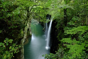
Takachiho should be at the top of the list of every Kyushu itinerary. The gorge is another
miracle of nature, with its vertical rock formations surrounding the steep crevices that
drop to the Gokase River. The best views are from the rowboats. Get close to the Manai
Waterfall and feel the roaring waters reverberate. You might even think the background
humming is a song of ancient myths and legends. If you are inclined to stay on the
ground, there is a trail that leads to a viewing point on the opposite side of the waterfall.
Here you can see the entire cascade.
Nearby Kunimigaoka is famous for a sea of clouds. You can drive all the way up to the
observation point. Both the parking lot and promenade provide a safe perch even in dim
light. The best time of year to see the white blanket is in the fall, when temperatures are
low and the air is still. A sea of clouds will form when the skies clear up after the rain,
but even if the conditions are not perfect for a full “sea” to develop, a dreamy landscape
can still materialize in the fog.
去九州旅行時,我一定會在早晨造訪高千穗。高千穗峽是一座四周環繞著柱狀紋理岩石的溪谷。真名井瀑布令人感覺很神祕,似乎一直在傾洩一股不可思議的力量。希望有一天能從小船上抬頭仰望瀑布。這是從橋上拍攝的風景。蹲在路上,從微小的空隙間拍照,成功拍出身處於綠意盎然的自然中的氣氛。從這裡走上步道,兩三分鐘就可以看到瀧見台展望台。這座熱門的觀景台可以遠望真名井瀑布,感受瀑布的浩大規模。高千穗也是知名的雲海名勝,雨後天晴時特別容易出現雲海。國見丘展望台可以開車前往,也設有停車場和步道。只要條件都具備的話就能從這裡俯瞰絕美的雲海。
15 minutes by car from the Takachiho Bus Center.
About Takachiho → Takachiho Tourist Association
kagoshima
Sakurajima

One of the iconic landscapes of Kagoshima Prefecture is a former island. Years ago,
Sakurajima was actually a separate land mass. Today it is contiguous with the rest of
Kyushu, the result of molten rock filling the channel when Sakurajima erupted in 1914. It
is still an active volcano, repeatedly spewing lava and ashes around it.
Best known as the birthplace of Saigo Takamori, an influential leader of the Meiji
Restoration during the late 19th Century, Sakurajima is a uniquely rich land full of history,
a distinctive culture and delectable dishes. About those local goodies: shirokuma is a
sweet treat of creamy shaved ice topped with candies and fruits like jewelry tossed on
snow. You have to try it.
櫻島是鹿兒島縣代表性的風景,屬於活火山,至今仍不斷噴發。1914 年的大噴發中有大量熔岩流出,島嶼的一部分因而與陸地相連。儘管從鹿兒島市內看過來宛如浮在海上的島嶼,但從垂水市可以走陸路上島。我想拍攝滿滿的船,便在港口拍了這張照片。
之後,我走國道 220 號線進入櫻島,環島一圈。島上設有眾多觀景處。難得來訪,我也想吃一次鹿兒島的美食。白熊冰是在刨冰上擺了葡萄乾、櫻桃、橘子和香蕉等大量水果的甜點,彷彿在雪上鑲了寶石一樣。能在蓬鬆刨冰與甘甜煉乳味的襯托下品嘗水果的滋味,好吃極了。
From Kagoshima, 15 minutes by ferry from the Sakurajima Ferry Terminal or 70 minutes by bus from Kagoshima Airport to Sakurajima-guchi bus stop. This view: Satsuma Bay side of Tarumi City.


Home / Shinrinyoku / Travel Japan / About us / Contact